K2 Base Camp Trek
Karakoram, Gilgit-Baltistan, Pakistan
0/5
0% of guests recommend
Duration
21 Days
Group Size
12 persons
Overview
About the K2 Base Camp Trek
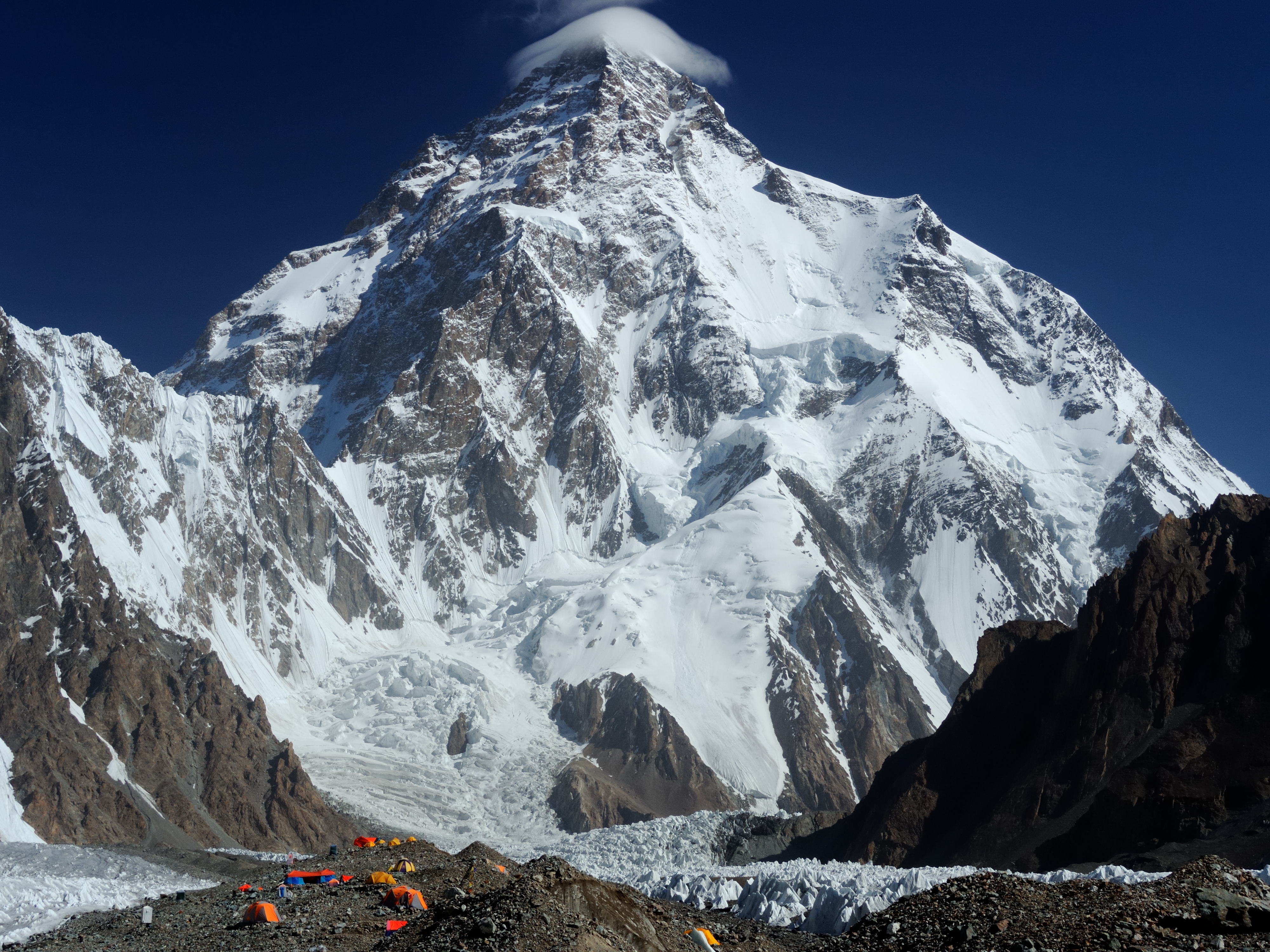
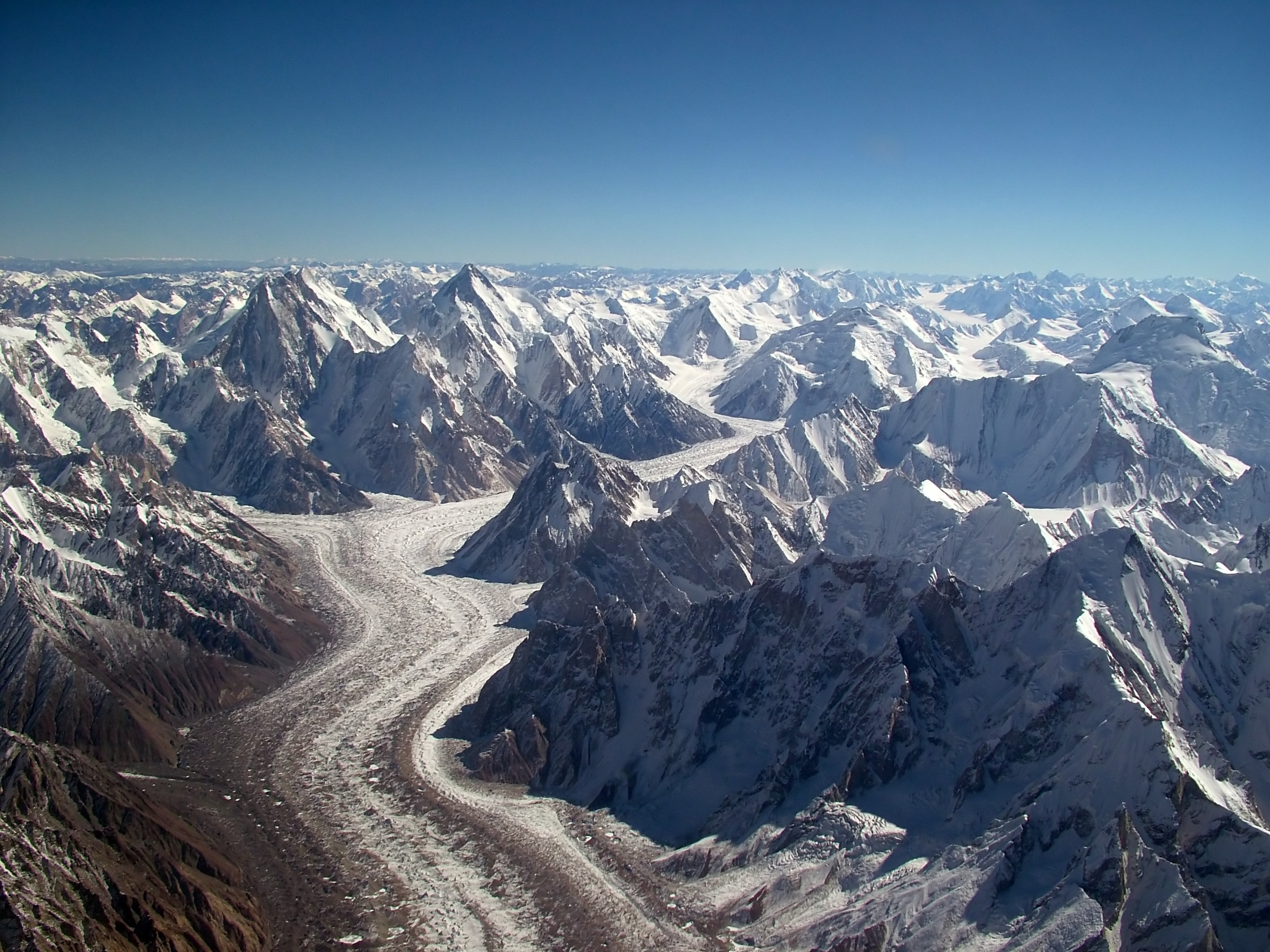
K2 stands at 8,611 metres on the border between Pakistan and China. It is the second highest mountain on Earth and the most dangerous of all the 8,000-metre peaks, with a fatality rate approaching 25 percent of all summit attempts. Getting to K2 Base Camp at 5,150 metres on the Pakistani side requires a 20-day commitment that takes you across the Baltoro Glacier, the longest glacier outside the polar regions, through some of the most dramatic mountain scenery in the world. This is the full Baltoro experience, from Askole village to the foot of K2 and back, covering approximately 160 kilometres of glacier walking.
The trek is physically demanding and logistically complex, but it is not technically difficult. There is no climbing, no fixed ropes, and no need for mountaineering equipment. The challenges are altitude, rough terrain, and sustained physical effort over 14 glacier days. The rewards are proportionate: two nights at K2 Base Camp below the Abruzzi Spur, two nights at Concordia with four 8,000-metre peaks in simultaneous view, and the entire Baltoro Glacier experience in between.
Route Overview
From Islamabad a morning flight takes you north to Skardu at 2,228 metres in one hour. The Skardu acclimatization day is followed by the Braldu Valley jeep drive to Askole at 3,050 metres, the last permanent settlement before the glacier begins. From Askole the trek follows the Baltoro Glacier northeast through camps at Jhola (3,170 m), Paiju (3,400 m), Urdukas (4,050 m), and Goro II (4,270 m) before reaching Concordia at 4,691 metres. From Concordia you walk the Godwin-Austen Glacier north for 8 kilometres to reach K2 Base Camp at 5,150 metres. Two nights at base camp. Then the return follows the same glacier route in reverse back to Askole and Skardu.
Glacier Approach Stages
The approach is structured in stages with each section offering its own character. The lower Baltoro from Askole to Paiju crosses the terminal moraine and the first true glacier terrain, reaching the last green camp at Paiju with its clear stream and rest day. The middle Baltoro from Paiju through the Trango Towers section to Urdukas offers the finest views of the approach, with Nameless Tower's 1,200-metre east face directly beside the trail. The upper Baltoro from Urdukas to Concordia crosses the most ice-dominant terrain and delivers the arrival view at Concordia. The K2 section from Concordia up the Godwin-Austen Glacier is the final and most powerful stage, culminating at the foot of the world's most dangerous mountain.
Best Time to Trek
July is the optimal month for the K2 Base Camp Trek. Baltoro trekking permits open in mid-June and the season runs through mid-August. July offers the most stable weather, the firmest glacier surface conditions, and the clearest views on the upper Baltoro. The residual monsoon moisture that reaches the Karakoram in July typically produces only afternoon cloud and occasional light rain rather than the sustained precipitation that defines the Nepal monsoon season. August is also good but early autumn snowfall can affect the upper glacier from late August onward. June is feasible but the upper sections often carry late-season snow that slows progress.
Difficulty and Physical Preparation
The K2 Base Camp Trek is strenuous. Ten consecutive days of 6 to 9 hour walking on rough moraine terrain, with multiple nights above 4,000 metres and a high point of 5,150 metres, requires genuine physical preparation. The terrain is unlike smooth mountain trails: Baltoro moraine is loose, rocky, and uneven and demands attention on every step. Altitude sickness is a real risk and is managed through the pacing and rest days built into the schedule. We carry a portable altitude chamber and emergency medications. Our guides are wilderness first aid trained.
The preparation minimum is being able to hike 20 kilometres on rough ground with a 12-kilogram pack in a single day without injury. Beyond raw fitness, tolerance for discomfort, altitude, and sustained physical challenge over multiple days is the key attribute. Prior high-altitude experience above 3,500 metres is recommended. Most people who attempt the K2 Base Camp Trek with adequate preparation complete it successfully and describe it as the finest trekking experience of their lives.
Culture Along the Baltoro
The Braldu Valley and Askole village are the homeland of the Balti people, a Tibetan-origin community who have lived in these high Karakoram valleys for centuries. Balti culture reflects its geographic position at the crossroads of Tibet, Central Asia, and South Asia. The porters who make the Baltoro trek possible are from this community. Their wages and working conditions are regulated by the Pakistan Alpine Club and porter welfare is taken seriously by responsible operators. Interaction with the porter team is one of the genuine cultural highlights of the trek. These are men who know the glacier intimately, who have crossed it in conditions that would stop most recreational trekkers, and whose families have built their livelihoods on the expeditions that pass through their valley.
Why Choose This Trek
The K2 Base Camp Trek gives you the full Baltoro experience including both the two-night stay at K2 Base Camp that the shorter Concordia Trek includes as a day trip. Standing at the foot of K2 for two days, watching the light change on the Abruzzi Spur across the morning and afternoon, reading the memorial plaques for eight decades of climbers, and looking directly up the route that leads to the world's most dangerous summit is an experience of a different order than a day visit. We handle all permits, guides, porters, camp equipment, and meals. You carry only your daypack. Groups are capped at 12.
Customized/Private Groups PricingDiscount will be automatically applied during the booking process if the number of guests meets the criteria specified in table below.(currently discounts are applicable to private tours only)
| Solo Price | 2 to 4 Person | 5 to 8 Person | 9 to 20 Person |
|---|---|---|---|
| $4,500 | $3,000 | $2,400 | $2,300 |
Itinerary
Day 1: Arrival in Islamabad
Altitude: 507m | Welcome dinner and briefing
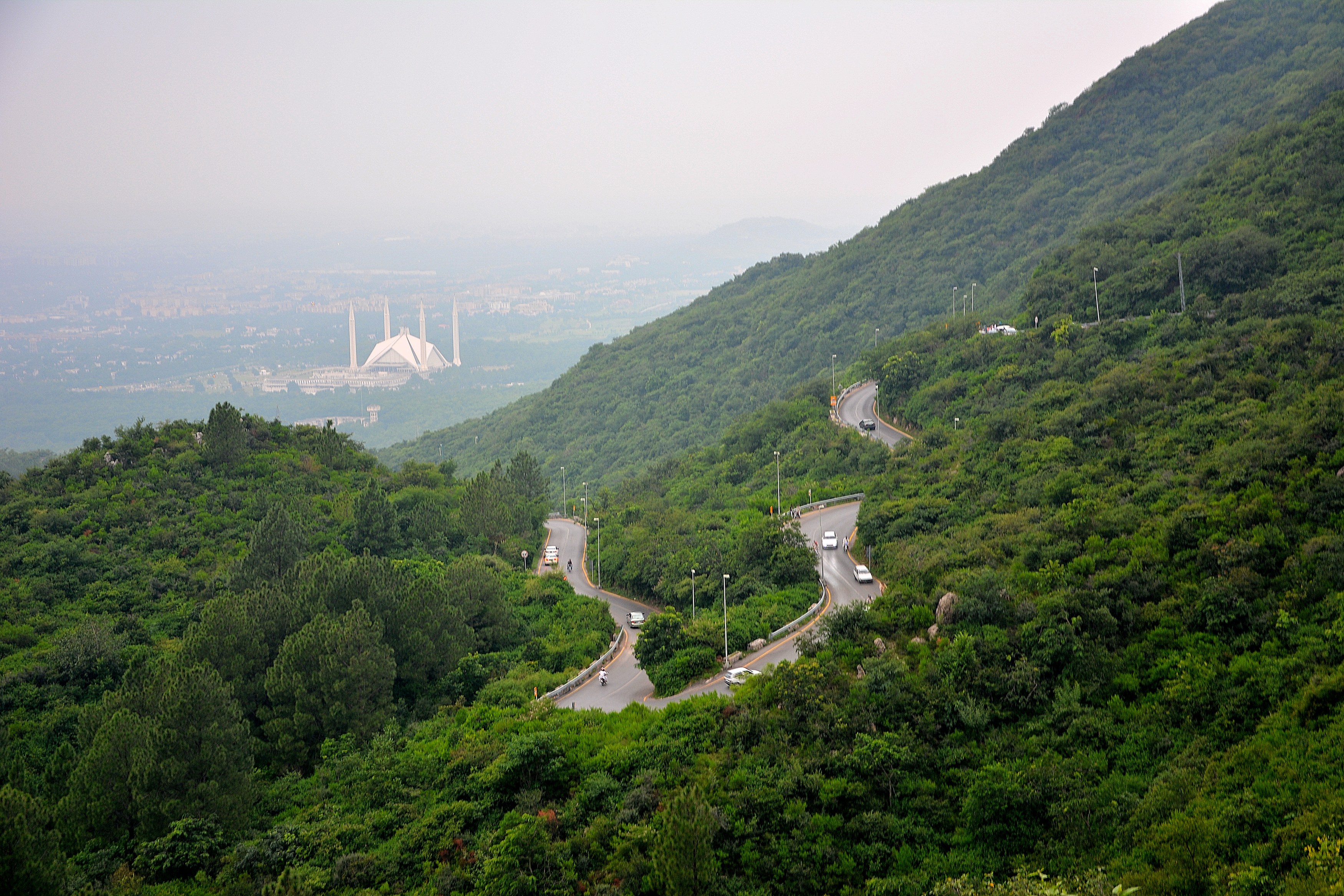
Your World of Mountain guide meets you at Islamabad Benazir Bhutto International Airport arrivals hall, holding a sign with your name. The transfer to your hotel in the F-6 or F-7 diplomatic enclave takes 30 to 45 minutes depending on traffic. Islamabad sits at 508 metres above sea level, the starting altitude before you begin your gradual ascent toward 5,150 metres over the coming weeks. The city is Pakistan's planned capital, built in the 1960s, and noticeably greener and quieter than Karachi or Lahore. Wide tree-lined avenues, the Margalla Hills rising above the northern suburbs, and the absence of the chaotic traffic typical of South Asian capitals all make the first impression a pleasant one.
In the afternoon you can explore the local area near your hotel. The Aabpara market is 10 minutes on foot and has gear shops where you can pick up anything you forgot at home. Quality headlamp batteries, trekking socks, sunscreen with SPF 50 or above, and snack bars are worth buying here if your kit is incomplete. The Kohsar market nearby has good coffee shops and restaurants where you can eat your first Pakistani meal at leisure. Islamabad cuisine is less spicy than Lahori food and includes excellent grilled meats, daal, and fresh bread from clay ovens. Drink only bottled water throughout Pakistan.
Your guide meets you at dinner to run through the full 20-day schedule, introduce the support team, and answer questions. They will check your kit list and flag any missing items you should buy tomorrow morning before the airport. Specifically confirm you have a sleeping bag rated to minus 20 Celsius, trekking poles, and sunglasses with side shields or glacier glasses. Your guide collects your passport copies for the permit paperwork at this meeting. Sleep as early as possible because the Skardu flight departs at 6 AM or earlier and the airport transfer requires a 4 AM departure from the hotel.
Day 2: Islamabad to Skardu by Flight
Altitude: 2,228m | Flight 55 minutes
Your guide knocks on your hotel room door at 3:45 AM. Breakfast is a packed meal the hotel prepares the night before. The drive to Islamabad airport takes 20 minutes at this hour with no traffic. Skardu flights operate only in the morning because by 9 AM thermal winds rising from the Karakoram valleys make landing at Skardu Airport unreliable. Pakistan International Airlines operates the route on ATR-72 turboprop aircraft carrying about 68 passengers. The check-in process is straightforward but allow 90 minutes before departure for luggage weighing and security. The airline has a 20 kg luggage limit and enforces it on this route.
The one-hour flight north over the Karakoram is one of the most scenic short flights in the world on a clear day. You take off heading north from Islamabad and almost immediately the Margalla Hills give way to the first high ridges. Watch from the left side of the aircraft about 40 minutes into the flight. Nanga Parbat at 8,126 metres appears above the cloud line, its Rakhiot Face recognisable from photographs. The Indus Valley is visible far below as the plane descends into Skardu. The airport runway sits at 2,228 metres on a flat terrace above the Indus River. Landing at Skardu is a reliable experience in clear weather but the flight is routinely cancelled in cloud or wind, sometimes for multiple consecutive days. If that happens, the overland alternative via the Karakoram Highway to Gilgit and Skardu takes 18 to 20 hours.
You arrive in Skardu by 8 AM on a normal day. A vehicle meets you at the airport and drives you to your hotel in Skardu town, 15 minutes away. Skardu town at 2,228 metres feels dramatically different from Islamabad. The bazaar is lined with small shops selling everything from dried apricots and walnuts to mountaineering equipment and Balti handicrafts. In the afternoon visit Kharpocho Fort on the rocky hill above town. The fort dates to the 16th century and the 30-minute climb to the top gives panoramic views of the Skardu Valley and the Indus River. If you have energy, Satpara Lake is 8 kilometres south of town and reachable by taxi. The water is clear turquoise and the surrounding mountains reflect in it on calm days. Tonight you sleep in a hotel with a proper bed. Tomorrow you drive the Braldu Valley jeep road to Askole.
Day 3: Skardu Acclimatization and Sightseeing
Altitude: 2,228m | Rest and acclimatization
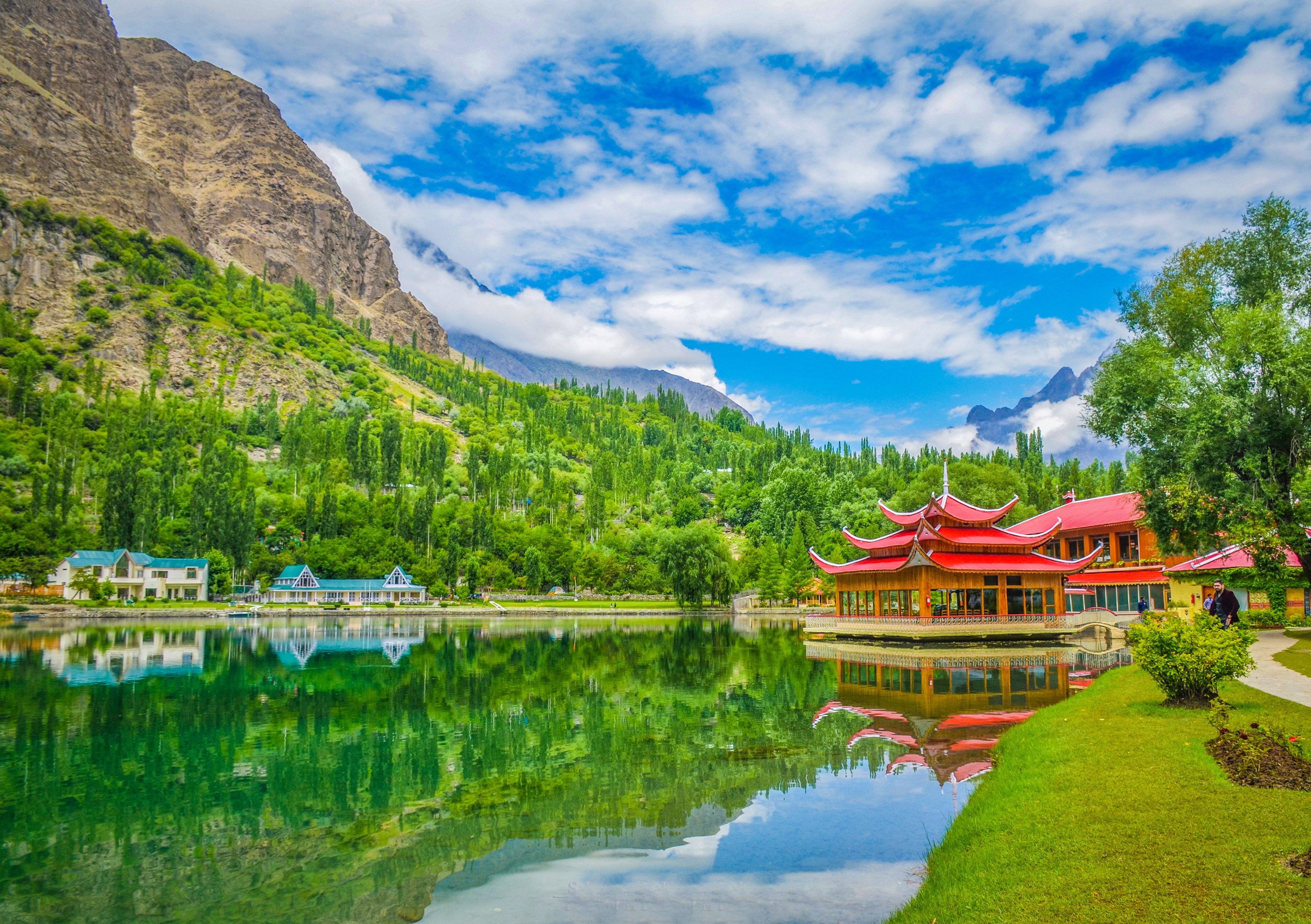
This full rest day in Skardu is not wasted time. Your body needs at least 24 hours at 2,228 metres before moving to higher altitude. The acclimatization process starts now even though 2,228 metres feels entirely comfortable. Walking around town, climbing to the fort, and staying active at this altitude triggers physiological adaptations that will matter significantly on day 11 when you are above 4,500 metres. Use the morning for a thorough gear check spread out on your hotel room floor. Every item matters at altitude so this is the time to identify gaps. The Skardu main bazaar has surprisingly good gear shops concentrated near the central market area that stock Pakistani-made trekking equipment alongside imported brands brought in from Islamabad.
Skardu is the capital of Baltistan, the high-altitude district of Gilgit-Baltistan province. The Balti people are ethnically distinct from the Hunza people to the northwest and speak a dialect of Tibetan. They are primarily Shia Muslim and the region has a long history of trading relationships with Tibet, Central Asia, and the Mughal Empire. The bazaar in the afternoon is worth a slow walk. You will see dried apricots and mulberries stacked in enormous mounds at fruit shops, freshly baked Balti bread called khambir at bakeries, and the inevitable clusters of mountaineering expedition teams from various countries loading jeeps for the drive to Askole. In July and August the Skardu bazaar is one of the most cosmopolitan places in Pakistan with climbers and trekkers from Europe, Japan, Korea, and the Americas all converging on the same supply depots.
Your guide uses this day to finalise the porter team, complete the permits at the Pakistan Alpine Club liaison office in Skardu, and confirm the jeep convoy for tomorrow's drive to Askole. You do not need to attend these logistics sessions unless you want to. A good use of the afternoon is a taxi ride to Shigar, a historic Balti village 30 kilometres from Skardu with an exceptionally well-preserved fort and palace now converted to a heritage hotel. The Shigar Fort Residence is one of the most beautiful buildings in northern Pakistan and worth a visit even if you are not staying there. The drive through Shigar Valley gives you a first taste of the Karakoram mountain architecture before the trek begins in earnest.
Day 4: Skardu to Askole by Jeep
Altitude: 3,015m | Jeep drive 56 hours
Breakfast in Skardu at 6 AM, then load your main trekking bag into the jeeps. The drive to Askole starts by 7 AM. From Skardu town you head south through the Indus Valley for about 45 minutes before the road turns east at Shigar Bridge and follows the Braldu River into its gorge. The Braldu Valley is one of the most dramatic jeep drives in Pakistan. The road was carved into the cliff face in the 1980s to support expedition traffic to the Baltoro Glacier. In sections the road is barely wide enough for a single vehicle and the drop to the Braldu River below is several hundred metres. The drivers know every metre of this road and handle it with practiced ease, but gripping the door handle is understandable for first-time passengers.
The Braldu River runs a bright milky green from glacial sediment throughout the summer. As you drive deeper into the gorge the valley walls close in and the sky narrows above you. Villages appear periodically on the few flat terraces, surrounded by small apricot orchards that have been cultivated here for centuries. The driver stops at Dassu, a small settlement roughly halfway to Askole, for a tea break. Hot chai with milk and sugar costs almost nothing and the chance to stretch your legs on flat ground is welcome. From Dassu the road continues east for two more hours. The final section before Askole passes through a wider flat area where the valley opens up and you see the first high peaks ahead. Paiju Peak appears for the first time on the skyline to the east.
You reach Askole village at 3,050 metres in the early afternoon, about 4 to 5 hours after leaving Skardu. Askole is the last permanent settlement before the Baltoro Glacier starts. About 700 people live here year-round, farming wheat and potatoes in a short growing season at this altitude. The village has a small number of basic guesthouses that accommodate trekkers. Your cook team sets up the kitchen and prepares the first proper camp meal of the trek, typically a substantial dinner of rice, lentil daal, chicken or mutton, vegetables, and fresh chapatti. After dinner your guide introduces the full porter team and explains the morning procedure. Most porter teams for Baltoro treks include 20 to 40 licensed porters carrying group equipment, food supplies, and personal gear at a regulated load of 25 kilograms per person. Sleep early. Tomorrow is the first full trekking day and it is long.
Day 5: Askole to Jhola Camp
Altitude: 3,170m | Trek 67 hours, ~12km
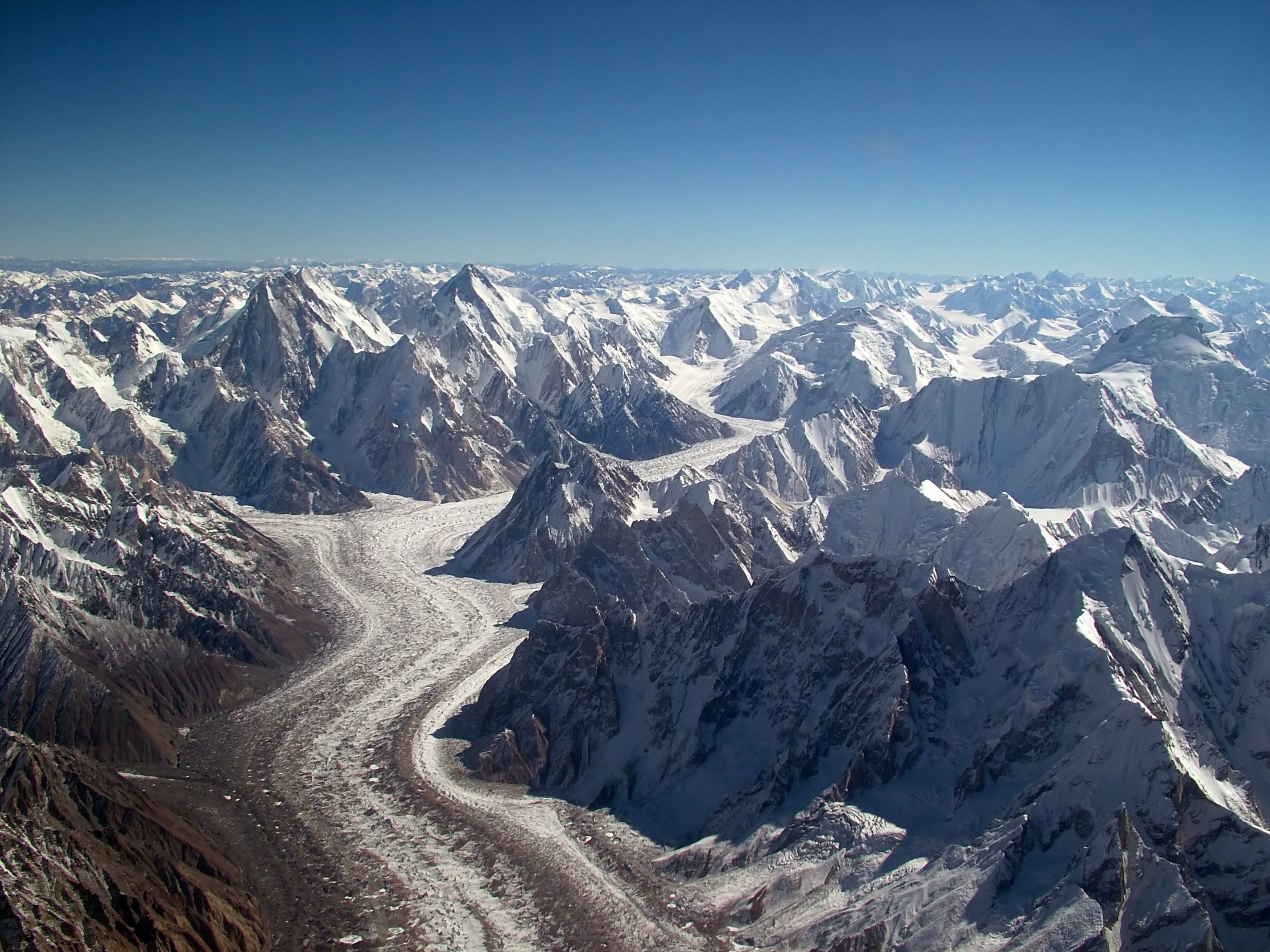
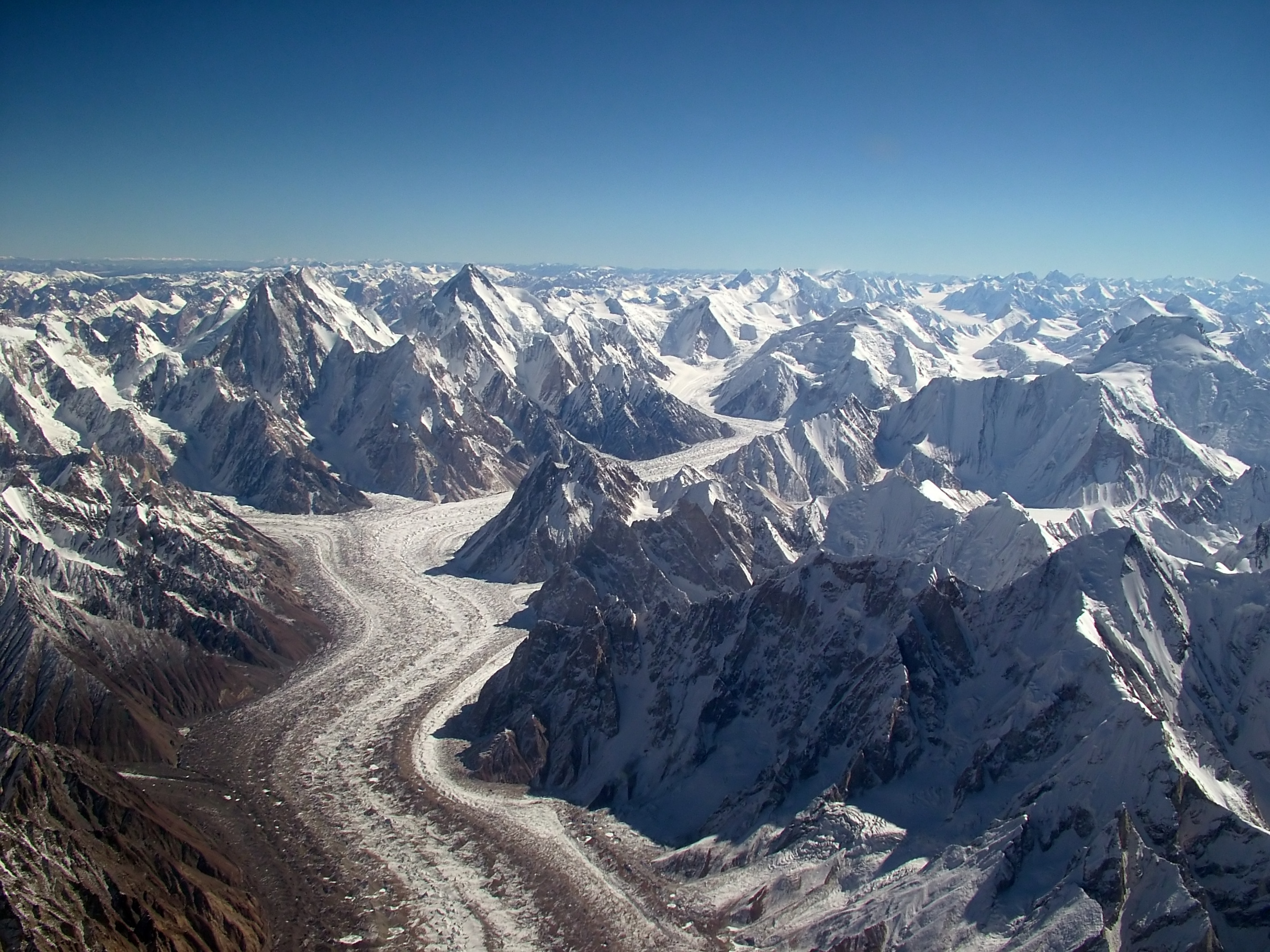
Wake at 5:30 AM. Breakfast by 6 AM, tents down by 6:30 AM, walking by 7 AM. This timing is standard throughout the trek. The morning hours before 10 AM are when the air is clearest and coolest. After 10 AM the glacier starts to radiate heat and the afternoon can be surprisingly warm despite the high altitude. Today covers approximately 14 kilometres from Askole to Jhola Camp and takes 5 to 7 hours depending on your pace. The trail starts on a sandy path above the Braldu River east of Askole, climbing gently through boulder fields and gravel flats. After about two hours you reach the terminal moraine of the Baltoro Glacier, the massive ridge of rock debris that marks where the glacier ends and has pushed material downvalley over thousands of years.
You cross a wire bridge over the Braldu River at the point where the glacier meets the valley floor. From here the route follows the left bank moraine of the Baltoro Glacier. Moraine walking is distinctive terrain: loose, rocky, uneven ground composed of boulders and gravel that the glacier has deposited and continues to push forward. There is no single clear path. Your guide picks the most efficient line through the rocks. The glacier itself is visible to your right as grey and brown ice mixed with rock debris. This is nothing like the blue glaciers of television documentaries. The Baltoro carries so much rock debris on its surface that the ice beneath is largely hidden. Large sections look more like a gravel plain than a glacier until you notice the subtle movement and the crevasses running beneath the surface.
Jhola Camp sits at approximately 3,170 metres on a flat sandy area at the glacier edge. You arrive in early to mid-afternoon. The porters arrive in the same window and begin setting up the kitchen and tent area. Your sleeping tent and dining tent will be pitched and ready within 30 minutes of your arrival. Dinner is served around 6 PM. After dinner the temperature drops quickly. At 3,170 metres a clear night sky holds more visible stars than most people have ever seen. The Milky Way is easily visible as a solid band across the sky. Bring your headlamp to walk around after dark since the moraine is treacherous in the dark without light. Tomorrow is a shorter day to Paiju Camp where you will have a full rest day.
Day 6: Jhola to Paiju Camp
Altitude: 3,410m | Trek 67 hours, ~14km
Today covers 11 kilometres from Jhola to Paiju Camp and takes approximately 5 to 6 hours. The route continues along the left bank of the Baltoro Glacier on moraine terrain that becomes progressively more established as you go deeper into the range. The morning walk is mostly flat to gently rising. After about three hours Paiju Peak begins to dominate the view ahead. Paiju Peak sits at 6,610 metres and is recognisable by its steep rock face and sharp summit ridge. It was first climbed by a Japanese expedition in 1977 and is considered a serious technical challenge. From the moraine trail the peak looks almost directly overhead when you are close to it.
The Baltoro Glacier surrounds you now and the scale of it is worth pausing to appreciate. At its widest the glacier spans 2.5 kilometres from bank to bank. The ice beneath the rock debris is estimated to be over 300 metres thick in the central channel. The glacier moves at roughly 1 metre per day in summer, a slow but powerful force that has been reshaping this valley for millions of years. Scattered across the moraine surface you can see meltwater pools in vivid blue and aquamarine where ice has melted below the rock cover and filled small depressions. These pools are not safe to walk near because the ice beneath is unstable.
Paiju Camp at 3,400 metres is one of the most pleasant campsites on the entire Baltoro route. Unlike the grey gravel of Jhola, Paiju has a strip of green grass and scrubby vegetation at the edge of the moraine. A small clear stream runs alongside the camp. The contrast between the grey of the glacier and the green of Paiju Camp makes the arrival feel like crossing a threshold. This is the last green vegetation you will see until the return journey 10 days from now. The stream water at Paiju is clean and cold, sourced from higher snowmelt rather than the silty glacial melt. Fill your water bottles here and drink plenty. Above Paiju all drinking water comes from glacier melt and requires treatment.
Day 7: Paiju Rest and Acclimatization
Altitude: 3,410m | Rest day
Rest day at Paiju Camp. No trekking today and no required schedule. The temptation to push forward on a rest day is understandable but resist it. Your body needs this day to adjust to the altitude and the physical demands of the previous two days. Sleep as long as you want. Eat a full breakfast when you wake. The cook team serves hot porridge, eggs cooked to order, toast, and tea or coffee. The afternoon menu typically includes soup at lunch and a full hot dinner in the evening. Between meals the dining tent has biscuits, nuts, and hot drinks available throughout the day. Drink at least 3 litres of water today regardless of whether you feel thirsty. Dehydration accelerates altitude sickness and is one of the most common problems on Baltoro treks.
For the active among you, a walk up the hillside directly behind camp is worth 90 minutes. The hillside rises steeply above Paiju and gains 200 to 300 metres in elevation on a goat trail. From the top of this short climb you can see the full length of the lower Baltoro stretching southwest toward Askole and the full extent of the glacier system around you. The Trango Tower group is visible to the northeast for the first time, a dramatic cluster of rock spires that look closer and more vertical than they appear from the glacier floor below. Paiju Peak stands above you to the east in full profile. This is also a good spot to test your binoculars and see if ibex are visible on the rock faces above camp. They often are, small dots moving with surprising ease across near-vertical terrain.
Your guide uses this day to check all trekkers' health conditions individually. Tell your guide about any headache, nausea, or unusual fatigue. These are early warning signs of altitude sickness and are important to report early. Mild headache on the first night at a new altitude is normal and usually passes after a good sleep and extra hydration. Headache that worsens despite rest, or is accompanied by vomiting, confusion, or difficulty walking in a straight line, is serious and requires immediate descent. Our guide is trained in wilderness first aid and carries acetazolamide (Diamox) which helps some people acclimatize faster. Ask about it tonight if you want to discuss whether it is appropriate for you.
Day 8: Paiju to Khoburtse via Baltoro Glacier
Altitude: 3,835m | Trek 68 hours on glacier
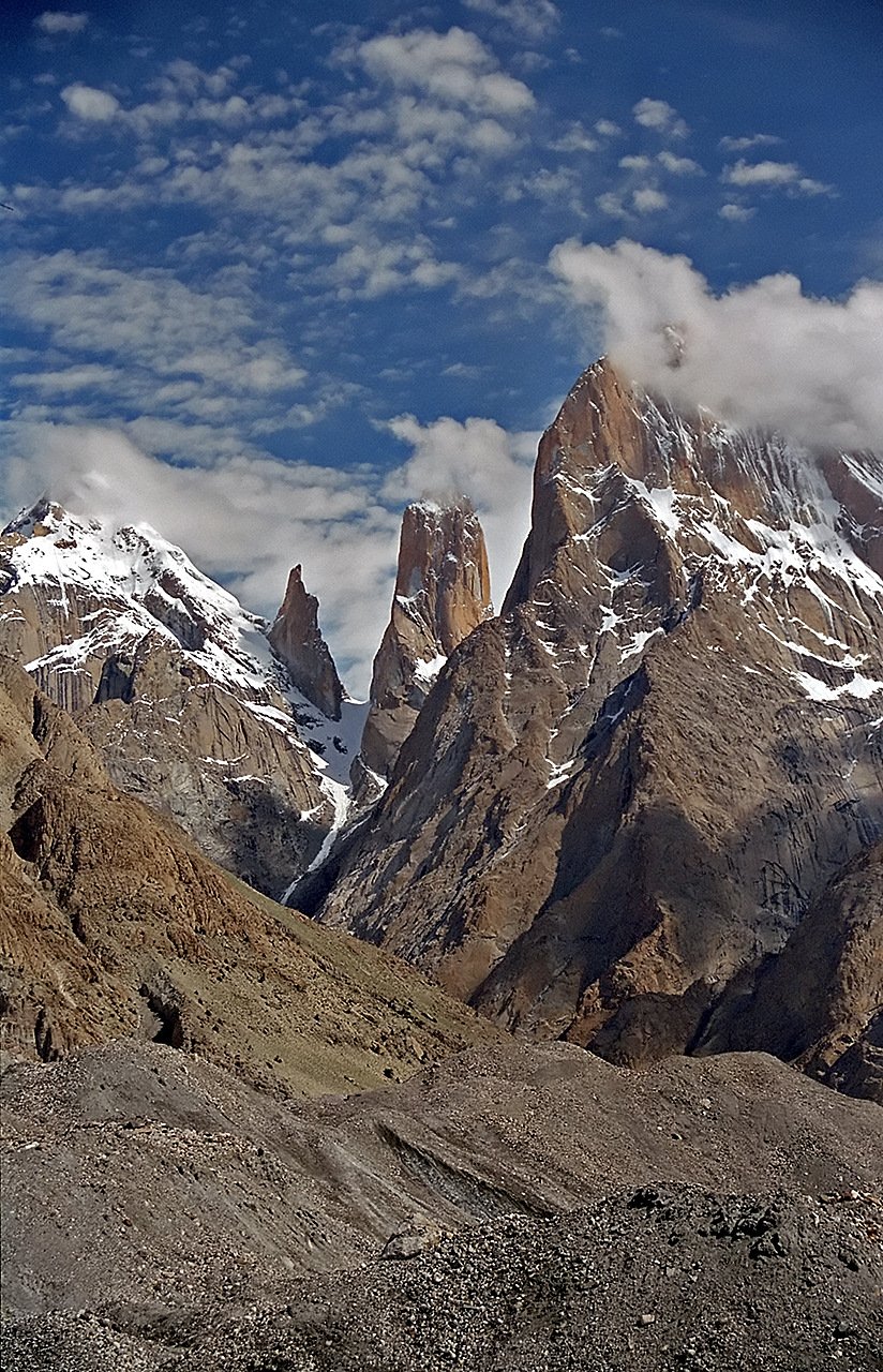
From Paiju the route follows the Baltoro Glacier surface and moraine for 10 kilometres to Khoburtse Camp, reaching the camp in approximately 5 to 6 hours. Leave at the usual 7 AM start. The morning's walk takes you off the grassy edge of Paiju and firmly onto the glacier moraine. The landscape shifts from the brief green respite of Paiju to the unbroken grey world of ice and rock that will surround you for the next 10 days. The Trango Tower group grows steadily more impressive as you walk northeast. Trango Nameless Tower at 6,286 metres is the tallest and most dramatic of the four main towers. Its east face is 1,200 metres of nearly vertical granite, one of the biggest rock walls in the world.
Khoburtse is not a marked village or formal camp but a flat rocky area below the Trango Towers that serves as the standard stopping point between Paiju and Urdukas. The Trango Towers are closest to the trail at Khoburtse and the view directly across to Nameless Tower is the best on the entire approach route. Many trekkers spend extra time here photographing. The light on the towers is best in the morning when the sun hits the east faces from the side and creates strong shadows that define the rock features. Binoculars reveal tiny figures on the wall when climbers are active, though in trekking season you are more likely to see fixed ropes and empty camps on the lower sections.
Khoburtse camp at roughly 3,850 metres provides a much-photographed perspective on the towers. The camp is more exposed than Paiju, sitting on open moraine with no shelter from wind or weather. Your cook team sets up a windbreak around the kitchen tent using natural rock formations. If wind is up in the evening, your sleeping tent stakes need checking after dinner. The temperature at 3,850 metres drops to around 5 Celsius on a clear July night. Your sleeping bag rated to minus 20 will keep you warm at this temperature with plenty of margin. Tomorrow is the short walk to Urdukas, one of the best-positioned camps on the Baltoro route.
Day 9: Khoburtse to Urdukas
Altitude: 4,050m | Trek 45 hours, ~8km
Urdukas to Goro II is 10 kilometres along the upper Baltoro moraine, taking 5 to 6 hours. Leave camp by 7 AM. The Trango Towers are behind you now as you head northeast toward the upper glacier. The route traverses from Urdukas's elevated rocky ledge back down to the glacier surface and then follows the moraine northeast. New peaks come into view as you push deeper into the range. Masherbrum at 7,821 metres dominates the view to the southeast. Its pyramid profile is one of the most distinctive shapes in the entire Karakoram, a near-perfect four-sided peak with steep ice faces and a sharp summit that was first climbed by an American-Pakistani team in 1960. K6 at 7,282 metres is visible further south and east.
The Baltoro Glacier at this altitude is noticeably wider and the surface is more complex. Ice towers called seracs appear in clusters between the rock debris. Some seracs reach 5 to 10 metres high before they melt and collapse. The glacier surface is no longer uniformly grey because the higher sections carry less rock debris and you start to see white and blue ice directly underfoot in places. Crevasses are present throughout this section but the moraine walking keeps you off the riskier central glacier. Your guide knows the route well and will direct you around problem areas. Do not wander off the established line on the upper glacier sections.
Goro II camp sits at 4,270 metres directly on the glacier surface, on a flat rocky area stabilised by moraine. This is the highest camp before Concordia and the altitude will be noticeable for the first time. Many trekkers experience mild headache on their first night at 4,270 metres. This is a normal acclimatization response and typically resolves by morning. Drink a full litre of water before sleeping and do not take painkillers to mask symptoms rather than treating the underlying dehydration and altitude stress. The cook team prepares a hot dinner and has warm water available after the meal. Sleep well. Tomorrow you reach Concordia.
Day 10: Urdukas to Goro II
Altitude: 4,285m | Trek 67 hours on glacier
Goro II to Concordia is 9 kilometres and takes approximately 4 to 5 hours. This is the walk that every person who has done the Baltoro describes as life-changing. Leave camp by 7 AM and walk northeast across the upper Baltoro. The glacier surface here is increasingly ice-dominant with less covering moraine. You walk on a combination of consolidated moraine ridges, open gravel flats, and occasionally bare ice. The route gains only 420 metres of altitude over 9 kilometres but every metre of it matters at 4,691 metres. Walk steadily and breathe deliberately. There is no benefit to pushing the pace on this section and significant cost if you arrive at Concordia too depleted to absorb the view.
About 500 metres before Concordia the Baltoro Glacier makes a turn to the left around a rocky promontory. As you round that bend, the view opens in front of you so suddenly that most people stop walking. This is one of the great mountain panoramas on Earth. K2 is directly ahead, 30 kilometres distant but filling the sky above the glacier with its black rock ridges and white ice faces. Broad Peak stands immediately to the right of K2 at 8,047 metres, its wide summit plateau giving the mountain its name. Gasherbrum IV at 7,925 metres is visible behind and to the left with its dramatic south face. Mitre Peak at 6,025 metres rises as a perfect pyramid to the south. You are standing at the confluence of the Baltoro Glacier and the Godwin-Austen Glacier, the point called Concordia.
Concordia camp at 4,691 metres is a flat gravel and ice area at the glacier junction. The cook team sets up camp while you absorb the panorama. Most people spend the first hour at Concordia simply looking. Photography from this spot rewards patience because the light on K2 changes dramatically from morning to afternoon. The black rock of the Abruzzi Spur is best lit in the late afternoon when direct sun hits the southeast face. The summit pyramid catches the last light well after the lower camps fall into shadow. Drink water consistently throughout the afternoon even if you do not feel thirsty. At 4,691 metres your kidneys are working harder and dehydration builds faster than you notice. Tomorrow you walk to K2 Base Camp.
Day 11: Goro II to Concordia
Altitude: 4,600m | Trek 56 hours, ~10km

Rest and acclimatization day at Concordia. You will need this day before the K2 Base Camp walk tomorrow. The altitude at Concordia is high enough that the body needs 24 hours of rest to prepare for the additional 460 metres to K2 Base Camp. Do not plan any significant exertion today. A short walk to a photography viewpoint above camp is fine but keep it under 1 hour and under 100 metres of altitude gain. Spend the day drinking water, eating well, and looking at the mountains. The light on K2 this morning is different from yesterday afternoon and will be different again tomorrow. Each hour of observation reveals new detail.
During the rest day your guide checks every trekker's condition systematically. At Concordia the guide uses the lake test: ask you to walk 10 metres in a straight line heel-to-toe. Loss of coordination is one of the early signs of high-altitude cerebral oedema, the most dangerous form of altitude sickness. The guide also checks for excessive fatigue, persistent headache unresponsive to water, unusual breathlessness at rest, or blue discolouration of lips and fingertips. None of these are common at 4,691 metres but they are possible and require immediate response if they appear. The portable altitude chamber we carry can simulate a 1,000-metre descent in an emergency while evacuation is arranged.
From Concordia you can see the route to K2 Base Camp clearly. The Godwin-Austen Glacier runs northeast from Concordia for about 8 kilometres to reach the base of K2's Abruzzi Spur. The glacier appears flat from Concordia but actually rises 460 metres over those 8 kilometres. You can see the moraine flats at the base of K2 from here on a clear day and even the small dots of expedition tents if a team is currently in residence. In July and August there are typically 2 to 5 international teams attempting K2 during the same season. Tonight, after dinner, your guide briefs the group on tomorrow's K2 Base Camp day including the timing, route, and what to expect when you arrive.
Day 12: Concordia Rest and Acclimatization
Altitude: 4,600m | Rest day
Concordia to K2 Base Camp is a 8 kilometre walk gaining 460 metres over approximately 3 hours. Leave Concordia at 7 AM carrying only a daypack. Your main tent and cook tent remain at Concordia where the porters stay. Bring water for the full day (at least 2 litres), snacks, sunscreen, glacier glasses, warm layers, and your camera. The route follows the right bank moraine of the Godwin-Austen Glacier. The walking is moderate and the path reasonably established. The glacier surface around you is increasingly ice-dominant as you gain altitude and distance from Concordia. Seracs are visible on the central glacier sections. Do not walk on the open glacier away from the moraine unless your guide specifically directs you.
K2 grows larger with every step. At Concordia it dominates the skyline. At K2 Base Camp at 5,150 metres it fills your entire field of vision when you look north. The Abruzzi Spur rises from the glacier directly above the camp. The route up the spur, which climbing expeditions use to attempt the summit, is partially visible from base camp: the lower snow couloirs, the fixed ropes on the House Chimney section, and the black rock ridges of the upper mountain. The summit pyramid at 8,611 metres is 3,461 metres directly above where you stand at base camp. The scale is unlike anything most people have experienced in their trekking lives.
At K2 Base Camp you find the remains of decades of expeditions: tent platforms built into the moraine, fixed rope anchors, old oxygen cylinders, prayer flags, memorial plaques for climbers who died on the mountain. The oldest plaques go back to the 1950s. There are memorials to over 80 climbers who have died on K2 since the first attempts began in 1902. Sit among them and eat your lunch. Many trekkers find this one of the most emotionally complex moments of the trek, an intersection of extraordinary beauty and extraordinary human cost. You spend 2 to 3 hours at base camp before walking back to Concordia. The return walk to Concordia takes 2 to 3 hours with the altitude mostly downhill.
Day 13: Concordia to K2 Base Camp
Altitude: 5,150m | Trek 45 hours, ~8km
You have a second day at K2 Base Camp today. You walk up again from Concordia, this time perhaps more slowly to appreciate details you rushed past yesterday in the excitement of the first arrival. Many trekkers find the second day at K2 Base Camp more emotionally resonant than the first because the initial shock of the view has settled and you can simply sit with it. Walk further along the moraine north of the main base camp area today if your energy allows. The moraine continues for another kilometre before the glacier becomes too crevassed to walk without equipment. From the north end of the moraine the view straight up the lower Abruzzi Spur is the closest ground-level view of K2's route that most non-climbers will ever have.
If an expedition is currently in residence at K2 Base Camp, which is likely in July or August, they will typically be happy to chat with trekkers who approach respectfully. The international climbing community is a small world and many expedition members are happy to talk about the mountain, the conditions, and what they are attempting. Ask your guide to make introductions if you are interested. The cook at the expedition base camp sometimes shares tea or snacks with visiting trekkers in a gesture of mountain hospitality. Do not approach expedition equipment, tents, or the route above base camp without an explicit invitation from the expedition team.
Return to Concordia in the early afternoon. From Concordia, looking back toward K2, the perspective is different from the base camp view. The full mass of the mountain above the glacier junction at 4,691 metres gives a sense of proportion that base camp, positioned directly at the mountain's foot, does not. This afternoon light on K2 from Concordia is arguably the finest view on the entire trek. If your camera battery is charged and your memory card has space, this is the moment to use both generously. Tonight is your last night at Concordia before the return journey begins tomorrow.
Day 14: Rest at K2 Base Camp
Altitude: 5,150m | Rest and exploration
The return begins today. From Concordia you walk back down the Baltoro Glacier to Goro II, retracing the 9 kilometres you walked in from the east on the approach. Leave by 7 AM as usual. The return is psychologically different from the approach because you know every landmark and can anticipate every section. The physical effort of walking is the same but the mental experience differs. You are moving away from K2 now rather than toward it. Many trekkers find the return journey more meditative than the approach, with the pressure of reaching base camp removed and a chance to notice details they missed when focused on getting to the destination.
Walking west on the return, the Trango Towers reappear ahead of you after several hours. They were behind you on the approach and now face you again as you descend. Broad Peak is visible over your right shoulder for much of the morning walk. Masherbrum appears to the south. The peaks that were ahead of you on the way in are now behind you. This reorientation of familiar mountains gives the return journey its own distinctive character. Weather often improves in the afternoon on the upper Baltoro, meaning the return can bring clearer conditions than the approach. Take the afternoon rest at Goro II to photograph peaks that were in cloud on the way up.
Goro II at 4,270 metres feels noticeably lower than Concordia and K2 Base Camp. Your breathing is easier here by a margin you can feel. The cook team prepares dinner at the usual time. The temperature tonight is slightly warmer than Concordia though still well below zero by midnight. Your sleeping bag keeps you comfortable. Tomorrow is a shorter day back to Urdukas, and then the days begin to shorten as you retrace the lower glacier sections toward Paiju and eventually Askole.
Day 15: K2 Base Camp to Concordia
Altitude: 4,600m | Return trek 45 hours
Goro II back to Concordia done. Today from Concordia you walk the section back down to Urdukas, about 20 kilometres covering both the Concordia-Goro II section and the Goro II-Urdukas descent, or alternatively you camp at Goro II one night as the standard schedule shows. From Goro II to Urdukas is 10 kilometres and takes 4 to 5 hours heading southwest. The Trango Towers grow closer and more dramatic as you approach them from the east. The views from this angle on the return differ from the approach because you are now lit differently by the sun position in the afternoon rather than the morning.
Urdukas camp at 4,050 metres occupies one of the most scenically positioned sites on the entire Baltoro route. The camp sits on a rocky terrace raised above the glacier surface, giving a panoramic view up and down the glacier in both directions. To the northeast you can see all the way back toward Goro II and in very clear conditions you can spot the turn in the glacier where Concordia lies. To the southwest the Trango Towers fill the view on the northern bank. Masherbrum rises to the southeast. The view from Urdukas in late afternoon light when the sun is low from the west and casting long shadows up the glacier is one of the most memorable views of the entire trek.
Camp at Urdukas tonight. The cook team sets up in the wind-sheltered area below the rocky ledge where tents are traditionally pitched. A short walk up the slope above camp in the evening gives an even wider view than the camp itself. Bring a warm jacket for this evening walk because the wind picks up on exposed rocky terrain after sunset. Tomorrow is the walk back down past the Trango Towers to Paiju Camp, a longer day of about 14 kilometres that brings you back to the last green vegetation before Askole.
Day 16: Concordia to Urdukas
Altitude: 4,050m | Trek 6 hours
Urdukas to Paiju is 14 kilometres and takes 5 to 6 hours, one of the longer return days. Leave camp at the standard 7 AM. The route descends from Urdukas's elevated ledge back down to the glacier moraine and heads southwest. The Trango Towers are directly to your left for the first two hours of the morning walk. From this angle on the return you see the south faces of the towers rather than the east faces that you saw on the approach. The lighting at this time of day and from this direction gives the rock a warmer colour than the morning shadows of the approach. Climbers' fixed ropes on the lower sections of the towers are sometimes visible through binoculars.
The moraine on this section of the Baltoro is well-travelled and you can move at a reasonable pace without too much concentration on foot placement. Your legs and lungs have been well conditioned by 10 days of glacier walking and the return feels notably less effortful than the approach. This is the acclimatization dividend: your blood has adapted to the altitude and your muscles have learned the moraine terrain. Enjoy the stronger feeling. It is real physiological improvement that took 10 days to build.
Paiju Camp at 3,400 metres is the return to green. After 10 days of nothing but rock, ice, and sky, the grass and scrubby bushes at Paiju Camp feel disproportionately lush. The stream running beside the camp is the cleanest and most refreshing water source on the entire trek. Wash your face and hands in it before dinner. The cook team makes a particularly good meal on the Paiju return night, which traditionally includes meat and an extra dessert course in recognition of making it back from K2 Base Camp. Tonight over dinner your guide leads a review of the full trek experience and everyone on the team shares their highlights. This is almost always a warm and memorable evening.
Day 17: Urdukas to Paiju
Altitude: 3,410m | Trek 67 hours
Paiju to Jhola is 11 kilometres and takes about 5 hours. The route retraces the approach in reverse. From Paiju the trail heads west and southwest on the left bank moraine. Paiju Peak is behind you now and shrinks with each kilometre you walk. The glacier on your right becomes progressively narrower as you approach the terminal moraine. The familiar landmarks of the approach pass in reverse order and the lower altitude makes the walking feel light and easy after the upper Baltoro section. Paiju Peak was 400 metres below your highest point at K2 Base Camp. Now it sits above you at 6,610 metres and looks high rather than close.
The terminal moraine section near Jhola requires careful walking. The loose boulder fields and gravel slopes are the same terrain you navigated on day 5 but now you are going downhill on them, which puts different stress on your knees. Trekking poles are most useful on this downhill moraine section. Use them with the pole length extended 10 centimetres longer than your uphill setting to absorb the downhill impact. Take your time on the loose ground and do not rush to beat the other trekkers into camp. Foot injury on loose moraine is the most common medical problem on Baltoro treks and is almost always caused by hurrying.
Jhola Camp at 3,170 metres is the second-to-last glacier camp before Askole. By the time you reach Jhola you can feel the air getting noticeably richer with each hundred metres of descent. Breathing is easy. Your appetite, which may have been reduced at altitude, returns fully. The cook team observes this and tends to serve larger portions from Jhola onward. Tonight will be cold because the sky is clear over the moraine, but noticeably less cold than Concordia or K2 Base Camp. One more trekking day remains before the jeeps.
Day 18: Paiju to Askole
Altitude: 3,015m | Trek 78 hours
Jhola to Askole is the final glacier day, approximately 14 kilometres taking 5 to 6 hours. This is the reverse of the first approach day. From Jhola you cross back over the bridge above the terminal moraine and follow the trail along the north bank of the Braldu River back toward Askole. The trail is well-defined and follows the river closely for most of its length. The terrain is progressively less rocky and more sandy as you approach the valley floor. Ibex are sometimes visible on the high rocky slopes above the river on this section. Lammergeier vultures with their enormous wingspans circle above the gorge walls regularly.
As you approach Askole the trail begins to pass through the outer fields of the village. Small stone-walled terraces hold late-season wheat and barley. The first apricot trees appear, their fruit either still green or freshly ripened depending on the timing of your visit. The smell of smoke from cooking fires and the sound of children reaches you before the village itself. After 10 days on the moraine this human sound and smell is profound. Askole after the Baltoro feels different from Askole before it. The first time you arrived here was the starting point of the unknown. Now you are returning from something, and the knowledge of what lies behind you on the glacier gives the place a different weight.
The jeeps are waiting at Askole for the drive back to Skardu. Before you load up, you pay the porter team their wages with your guide managing the distribution. Porter payment follows Pakistan Alpine Club regulations and the pay includes the return journey whether they walk with you or not. The 4 to 5 hour jeep drive back to Skardu through the Braldu Valley is rough but short compared to what you have been walking. You arrive in Skardu by early evening. Hot shower, proper hotel room, restaurant meal, and a comfortable bed. The 16 days of glacier walking are behind you.
Day 19: Askole to Skardu by Jeep
Altitude: 2,228m | Jeep drive 56 hours
You fly from Skardu back to Islamabad this morning. The departure time is early, same as the outbound flight. Get to the airport by 5 AM for a 6 AM departure. Check in the excess baggage you sent ahead to Skardu from Islamabad. The return flight gives you a final aerial view of the Karakoram from above, a perspective that makes the scale of the range comprehensible in a way that ground-level trekking does not. From the air you can trace the course of the Baltoro Glacier from its terminal moraine near Askole all the way back to Concordia and beyond. The peaks that surrounded you for two weeks appear as part of a continuous mountain system rather than individual giants.
In Islamabad you have the afternoon free before international departure. The Daman-e-Koh viewpoint in the Margalla Hills above Islamabad is a 15-minute drive from the city and gives a wide view over the capital and south toward the plains of Punjab. From this height you can see why the Margalla Hills were chosen as the backdrop for the planned capital: the transition from mountain to plain is sharp and the hills are a genuine geographical boundary. The Pakistan Monument near the Shakarparian Hills is another worthwhile stop, a star-shaped structure commemorating Pakistan's 1947 independence with detailed friezes showing scenes from every province.
Your guide takes you to the airport for your international departure. The Islamabad airport has been upgraded and handles a reasonable number of international connections. Depending on your destination you may connect through Doha, Dubai, Abu Dhabi, or Istanbul. The 20-day K2 Base Camp Trek is complete. You have walked roughly 160 kilometres on one of the world's great trekking routes, stood at the foot of the most dangerous mountain on Earth, and crossed the Baltoro Glacier twice. That is a meaningful achievement by any standard.
Day 20: Fly Skardu to Islamabad
Altitude: 507m | Return flight 55 minutes
Hotel departure at 4 AM for the early morning Skardu to Islamabad flight. The same weather-window rules apply as the outbound journey: the flight operates in the morning and afternoon cloud build-up over the Karakoram regularly causes cancellations. If cancelled, the same-day rebook is attempted. On a clear morning the return flight gives a final aerial view of the Baltoro system and the peaks you have been walking among for the past 18 days.
Landing in Islamabad, the transition from the high-altitude world of the Karakoram back to the lowland city is abrupt and recognisable to every returning expedition member. The heat, the density, the noise. The body adjusts to low altitude almost immediately. Transfer to your hotel in Islamabad for the final night. Your guide is available through the evening for any last logistics or questions about future travel in the region.
Day 21: Depart Islamabad
Trek ends | Transfer to airport
Departure from Islamabad. Transfer to Benazir Bhutto International Airport for your international flight. Check-out at the hotel is typically 12 noon and depending on your flight time there may be a final breakfast at one of Islamabad's better restaurants in the F-7 Markaz area.
The K2 Base Camp Trek covers 21 days and the full Baltoro Glacier corridor from Askole to K2 Base Camp at 5,150 metres and back. You have walked under the Trango Towers, spent nights at Concordia with eight 8,000-metre peaks visible simultaneously, and stood at the base of the world's second highest mountain. This is one of the most demanding and most rewarding trekking routes in the world and you have completed it.
Highlights
- Stand at K2 Base Camp at 5,150 metres and look directly up the Abruzzi Spur toward the summit of the world's most dangerous mountain.
- Cross Concordia at 4,691 metres and see K2, Broad Peak, Gasherbrum I, and Gasherbrum II all visible at once from a single point.
- Walk 62 kilometres of the Baltoro Glacier, the longest glacier outside the polar regions, on a route that changes character every day.
- See the Trango Towers at close range, four vertical rock spires including Nameless Tower at 6,286 metres considered one of the hardest rock climbs on Earth.
- Spend two nights at K2 Base Camp at 5,150 metres where dozens of expeditions have staged attempts on the world's most dangerous summit.
- Pass Masherbrum at 7,821 metres and Paiju Peak at 6,610 metres on the approach sections of the Baltoro.
- Drive the Braldu Valley jeep road, a rough track carved into the gorge walls above the emerald green Braldu River, one of the most dramatic road journeys in Pakistan.
- Experience complete night sky darkness far from any city, with the Milky Way visible clearly above the glacier on clear nights.
Included/Excluded
All accommodation (hotel in Islamabad and Skardu, camping on trek)
All meals during the trek (breakfast, lunch, dinner)
Domestic flights Islamabad to Skardu (return)
Jeep transfers Skardu to Askole (return)
Experienced licensed trekking guide
Professional mountain cook
Porters for all group camping and kitchen equipment
High-quality tents, sleeping mats, and cooking gear
All Pakistani government trekking permits
Porter insurance and wages as per government regulations
First aid kit and emergency oxygen
Airport and hotel transfers in Islamabad
International flights to and from Islamabad
Pakistan visa fee
Personal trekking equipment (sleeping bag, boots, clothing)
Personal porter for individual gear
Travel and medical insurance (mandatory for all trekkers)
Tips for guides, cook, and porters
Alcoholic beverages
Satellite phone or communication devices
Medical evacuation costs
Any expenses caused by flight delays or weather cancellations
Personal snacks and extra beverages
Things To know
Travel Insurance
- Comprehensive travel insurance is mandatory for all participants.
- Your policy must cover high-altitude trekking to at least 5,500 metres.
- It must include emergency medical evacuation by helicopter if required.
- Keep a digital and physical copy of your policy documents throughout the trip.
Packing Essentials
- 4-season sleeping bag rated to -15C minimum (not provided)
- Sturdy ankle-support trekking boots, well broken-in before the trek
- Thermal base layers and a quality down jacket for cold nights
- Waterproof jacket and trousers
- Trekking poles (strongly recommended on glacier terrain)
- UV-protective sunglasses and high-SPF sunscreen
- Wide-brim sun hat and warm beanie
- Blister plasters and basic personal first aid items
Altitude Awareness
- Ascend slowly and listen to your body above 3,500 metres.
- Stay well hydrated throughout the trek, drinking at least 3 litres per day.
- Avoid alcohol at altitude, which worsens dehydration and altitude sickness.
- Inform your guide immediately if you develop a persistent headache, feel nauseous, or struggle to breathe normally.
- Never ascend if symptoms of altitude sickness are present. Descend if they worsen.
Weather Conditions
- Daytime temperatures on the Baltoro Glacier in July and August range from 5C to 18C depending on altitude.
- Nights at Concordia can drop to -10C or below even in summer.
- Afternoon cloud and brief snowfall is common on the upper glacier.
- Be prepared for sudden weather changes at all times.
- Pack your gear inside waterproof bags or dry sacks.
Connectivity and Communication
- Mobile coverage and internet access end at Askole village.
- Our guides carry a satellite communication device for emergencies throughout the trek.
- Inform family and friends that you will be unreachable for approximately 12 consecutive days.
- Some trekkers carry their own personal satellite messenger devices such as SPOT or Garmin InReach.
Responsible Trekking
- Carry all personal rubbish out from the trail. Leave No Trace principles apply throughout.
- Do not collect rocks, flora, or any natural materials from the national park area.
- Respect local Balti culture. Dress modestly in villages and always ask before photographing people.
- Support the local economy by treating your guides, cook, and porters with respect and tipping fairly at the end of the trek.
- Follow all fire restrictions in place on the Baltoro. Open fires are not permitted above Paiju.
FAQs
How difficult is the K2 Base Camp Trek?
The K2 Base Camp Trek rates as strenuous on any objective scale. You walk 6 to 9 hours daily for 10 consecutive days after the Askole drive. The highest point is 5,150 metres at K2 Base Camp where the air contains approximately 53 percent of the oxygen available at sea level. The terrain is rough moraine walking, not smooth trail. Daily distance ranges from 9 to 16 kilometres. The cumulative physical demand is significant: roughly 160 kilometres total walking distance over the glacier sections plus the approach days.
That said, the technical difficulty is zero. There is no rock climbing, no fixed ropes, no crampons, no equipment beyond a trekking setup. The difficulty is entirely cardiovascular and muscular endurance combined with altitude management. A person who can hike 20 kilometres on rough terrain in a single day at low altitude, and who manages stress and discomfort well, is physically capable of this trek. Most people who fail on the Baltoro do so because of altitude sickness, not fitness. Being fit increases your odds of avoiding altitude problems but does not eliminate them.
Do I need previous high-altitude experience?
Previous high-altitude experience is strongly recommended but not technically required. Trekkers who have been above 4,000 metres before, even on something as relatively mild as the Everest Base Camp trek or the Annapurna Circuit, have a significant advantage. Their bodies have some memory of altitude adaptation and they have practical experience managing the symptoms. If this is your first time above 3,000 metres, the Baltoro is manageable but you should go in with realistic expectations about how the altitude might affect you personally.
The practical consequence of no prior altitude experience is that you do not know how your body responds. Some people acclimatize effortlessly and feel better than expected. Others get persistent headache that limits their enjoyment significantly. A small minority experience serious altitude sickness that requires descent. Without prior experience you cannot predict which category you fall into. If you have no previous high-altitude experience, consider doing a 3,000 to 4,000 metre trek in another mountain range before attempting the Baltoro.
What is the risk of altitude sickness?
Altitude sickness affects a significant minority of Baltoro trekkers. The most common form is Acute Mountain Sickness (AMS): headache, fatigue, loss of appetite, and disturbed sleep. AMS at the Concordia and K2 Base Camp altitude range is common and usually manageable with rest, hydration, and descent if symptoms worsen. Approximately 30 to 40 percent of Baltoro trekkers experience AMS symptoms severe enough to notice, though most push through with guidance.
Serious forms, High Altitude Pulmonary Oedema (HAPE) and High Altitude Cerebral Oedema (HACE), are rare on trekking routes because the pace of ascent is slow and the maximum altitude of 5,150 metres is not extreme by mountaineering standards. However, they do occur and require immediate response. We carry dexamethasone for HACE, nifedipine for HAPE, a portable altitude chamber (Gamow bag) that simulates a 1,000 metre descent, and an emergency satellite communicator. Our guides are trained in wilderness medicine. The protocol is simple: if symptoms are serious or worsening, descend immediately. We do not wait for confirmation of a diagnosis before descending.
What is the best time to do this trek?
Mid-June through mid-August is the reliable window. July is the statistically best month for both weather stability and Baltoro permit availability. The monsoon that dominates trekking conditions in Nepal arrives at the Karakoram much weakened, typically bringing only afternoon cloud and occasional rain rather than the sustained precipitation that closes Nepal routes. The glacier is most accessible in July when the snow bridges over crevasses are solid and the moraine surface is relatively dry.
June is possible but the upper Baltoro can have significant snow coverage that makes route-finding more challenging. September can bring early autumn snowfall to the upper glacier. The passes above Askole occasionally get early snow in late August. Early October is technically possible for experienced groups but increasingly risky for normal trekking conditions. May is generally too early because late-season snow on the approach trail above Askole can make the first days dangerous without snowshoes or crampons.
How fit do I need to be?
You need to be able to sustain 6 to 9 hour walking days on rough terrain for 10 consecutive days without injury. Test this before you go. Go on long hikes with a loaded backpack, at least 12 kilograms, on uneven ground for a full day multiple times before departure. Train on rocky or boulder-field terrain if available since this most closely mimics the moraine walking conditions on the Baltoro. Your knees take significant punishment on the return descent sections and pre-trip strengthening of quadriceps and hip flexors through squats and lunges pays dividends on the downhill sections from Concordia back to Askole.
Cardiovascular fitness is more important than raw strength for this trek. If you can run 10 kilometres continuously and hike 25 kilometres in a day without difficulty, your base fitness is adequate. If you cannot currently walk 20 kilometres without significant discomfort, commit to a 3 to 4 month training programme before departure including progressive long hikes, stair climbing, and if possible any training at altitude above 2,000 metres you can access. The trek will not be enjoyable if you are not physically prepared, and being underprepared puts pressure on guides and porters who then have to manage your rescue in addition to their existing responsibilities.
What equipment do I need to bring?
The Pakistan Alpine Club publishes an official equipment list for Baltoro trekking permits. Non-negotiable items include a four-season sleeping bag rated to minus 20 Celsius (do not bring a three-season bag rated to minus 5 and expect to be warm at Concordia), trekking poles (the moraine is dangerous without them), and glacier glasses with side shields rated for UV protection above 4,000 metres (not sunglasses with side arms, actual glacier goggles or large wrap-around glacier glasses). Standard sunglasses do not provide adequate UV protection on the highly reflective snow and ice of the upper Baltoro.
Warm layering is critical. The standard approach is a base layer, mid-layer fleece, and a down jacket or synthetic puffy jacket with a waterproof shell over the top. At K2 Base Camp the temperature can be above 15 Celsius at noon and below minus 5 at midnight. Your layering system needs to cover this 20-degree range comfortably. Bring hiking boots that have been broken in for at least 100 kilometres before the trek. New boots on the Baltoro guarantee blisters. Waterproof boots are better than non-waterproof because the glacier surface is wet in summer and crossing streams near camp gets boots damp even on dry days.
Is a Pakistan visa required?
Pakistan requires a visa for most nationalities. Citizens of a small number of countries including several Central Asian states can get a visa on arrival at Islamabad airport, but the majority of trekkers from Europe, the Americas, and Australasia need to apply in advance. Pakistan offers an e-visa through the official government portal that most nationalities can obtain within 3 to 7 working days for a cost of approximately 30 to 50 USD depending on nationality. Apply at least 6 weeks before departure to allow for any delays. Your passport must be valid for at least 6 months beyond your intended departure date from Pakistan.
What type of accommodation is used on the trek?
You sleep in hotels in Islamabad and Skardu with private rooms, hot water showers, and Western-style toilets. These range from basic mid-range to good quality three-star standard depending on availability and your booking preferences. From Askole onward you sleep in four-season dome tents supplied by us with closed-cell foam sleeping mats 3 centimetres thick. You provide your own sleeping bag. The tents are pitched by the porter team before your arrival at each camp. They are single or double occupancy depending on group size and gender composition.
Toilet facilities on the Baltoro are basic. Each camp has a toilet tent with a portable toilet seat over a dug pit or a cat-hole system where the ground is rocky. This is standard across all trekking groups on the Baltoro and there is no alternative. Bring a small trowel for any mid-day emergencies between camps and carry a small ziplock bag with toilet paper and hand sanitiser in your daypack at all times. The Pakistan Alpine Club requires all groups to pack out solid waste above certain altitudes and we comply with all waste management regulations.
Is there mobile coverage on the Baltoro Glacier?
There is no mobile phone coverage on the Baltoro Glacier. Signal disappears within a few kilometres of Askole village and does not return until you are back within range of the Askole cell tower on the return journey. Between Askole and Skardu on the return drive you regain signal in several valley towns. From the moment you leave Askole until you return 14 glacier days later, you have zero mobile connectivity.
We carry a two-way satellite communicator (typically a Garmin inReach or similar device) which allows text message communication with the outside world in emergencies and GPS tracking that your emergency contacts at home can follow online. If something serious happens on the glacier, this device is our connection to emergency services and evacuation coordination. Your family can be given the tracking link before you depart so they can follow the expedition's progress in near real-time without requiring any communication from your end.
What permits are required for this trek?
Three permits are required. First, a Baltoro Glacier Trekking Permit issued by the Pakistan Alpine Club in Islamabad. Second, a No Objection Certificate (NOC) from the Gilgit-Baltistan Department of Tourism. Third, entry documentation for the Khunjerab National Park if your route touches park boundaries, though for the standard Baltoro approach this is rarely required. We handle all three permits as part of the tour price. You provide passport copies and two passport photographs when you book. Permit applications are submitted on your behalf approximately 45 to 60 days before departure.
How large are the groups?
Maximum group size is 12 paying trekkers per permit. We typically run groups of 4 to 10 people. The smaller the group the more personal the guiding experience. Solo travellers are welcome and join existing group departures. If you want to be the only client with a private guide and porter team, that is possible at a higher cost. Private departures can also be scheduled outside the standard June to August windows if your work calendar requires a less conventional timing, though we recommend against trekking the Baltoro outside the established season window without a specific reason.
What happens if the flight to Skardu is cancelled?
Flight cancellations between Skardu and Islamabad are one of the most common logistical complications on Baltoro treks. In a typical summer season, 20 to 30 percent of Skardu flights are cancelled due to cloud, wind, or visibility issues at the mountain airport. Sometimes cancellations run for 3 or 4 consecutive days. We build a 2-day buffer into every itinerary specifically for this scenario. If the buffer days are consumed before we can fly, the fallback is the overland Karakoram Highway route: a 14 to 18 hour road journey from Skardu to Islamabad via Gilgit. The KKH drive is long but reliable and always gets you to Islamabad in time for an international connection if we have the buffer days to absorb the road time.
Can the trek be done as a private tour?
Yes, private tours are available for individuals, couples, or small groups. A private tour means your own departure date, your own guide, and complete flexibility to adjust the pace and schedule. Private tours cost more per person than shared group tours because all fixed costs including guide salary, permit fees, and cook team are divided among fewer people. Contact us with your preferred dates and group size for a private tour quote. The minimum viable group size for a private Baltoro trek on standard pricing is 2 people, though solo trekkers can also arrange private tours with adjusted pricing.
Tour Location
Karakoram, Gilgit-Baltistan, Pakistan
Reviews
0/5
Not Rated
Based on
0 review
Excellent
0
Very Good
0
Average
0
Poor
0
Terrible
0
No Review
11%
from
$2,600
$2,300
from
$2,600
$2,300